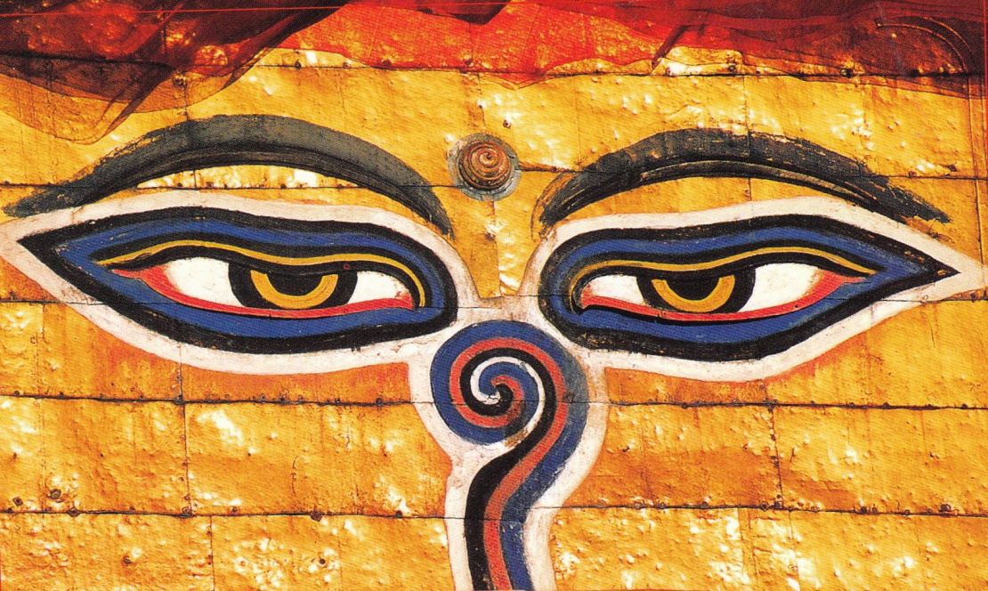
Enjoy the beauty of the Himalayas – Explore with local experts
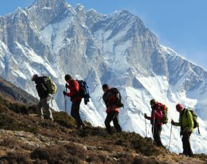
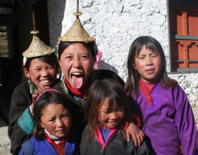
The trail is popular for having breath taking natural scenery, unique culture, rituals and lifestyles of people living in the western region, who have their distinct culture, and lifestyles and their hardship in the arduous environment. Saribung Peak lies in the Damodar Himalayan range close to the Nepal / Tibet border in the Upper Mustang region. The Nepal government opened this peak for climbing expeditions only in 2006. Reaching the summit of Saribung (6328m) is the ideal expedition for those wishing to get off the beaten track and ascend a peak that, to date, only a handful of climbers have reached.
The trails are rugged,cutting high into cliff sides and pass villages that have changed little over the years.Our Saribung Expedition is a relatively easy one for experienced mountaineers but it is physically demanding with the crossing of high passes like Saribung La at over 5600 m and Kang La at over 5200 metres.
Upon arrival in Kathmandu, you are met at the airport and transferred to your hotel. Our airport representativewill be waiting for you in the arrival hall, located after passing out of the customs area. Look out for the Himalayan hikers signboard. The drive from the airport to the hotel is around 20 minutes. A briefing given by our group leader is scheduled for the late afternoon. He will discuss our trekking program and co-ordinate any last minute arrangements. A visit to Thamel gives you a chance to do some last minute shopping. Later, we are supplied with ourTrek Pack and departure information for tomorrow. The evening is free, but usually our tour leader will organize an evening meal (optional) at one ofKathmandu’s fine Nepali restaurants. Alternatively you can enjoy a dinner at the hotel.
We depart from Kathmandu early in the morning for the drive to Bhulbule, via Dumre and Besishahar, where we commence the trek. The drive is quite spectacular with mountain views of the Ganesh and Manaslu Ranges, the tumbling white waters ofthe Trisuli River and the terraced hillsides. We will stop for lunch along the way. From our lodge, the views of the mountains are spectacular, with Himalchuli (7893m) dominating the skyline. Our full crew will assemble at Bhulbule. Meals included: B, L, D
From Bhulbule we follow the west bank of the Marsyandi River to the village of Syange (1136m), where we take lunch.In the afternoon we continue up the west bank of the Marsyandi River, starting to climb high above the river now, to the small village of Jagat, where we will stay in a lodge overnight.Jagat isa Tibetan village that once served as a customs post on the old trading route from Tibet. Meals included: B, L, D
Today the vegetation changes to rhododendron and pine forest and the valley becomes narrower and steeper. Wesoon cross the river on a large suspension bridge from where the trail ascends quite steeply and the river tumbles through a maze of large boulders. After reaching the top of the zigzag climb, amazingly the valley widens out to reveal the village of Tal, which nestles amongst the fields of barley, wheat and potatoes. We have now entered the district of Manang and take lunch in one of the many fine hotels here. The afternoon’s walkfollows the river valley, crossing back to the west bank before gradually ascending to Dharapani where we end our trekking day, again in a lodge. Meals included: B, L, D
The valley now turns westward through dramatic fir and pine forests. After half an hour we reach Bagarchap(2760m), the first village on the trek with typical Tibetan architecture. Here we may observe firewood stacked onthe roofs in preparation for the long, hard winters. The village marks the transition between the lower, wet valley sand the higher, more arid area of the Manang valley. There are excellent views of Lamjung Himal,Annapurna II (7937m) and Annapurna III (7555m) up the valley. Down valley to the east, Manaslu and Peak 29soar magnificently to the skies. Leaving Bagarchap, we cross a small wooden bridge beside a beautiful waterfall and ascend to Temang (2360m) for lunch. The trail then continues easily for about an hour and a half to the police check post at Koto where we stay in our last lodge accommodation for some time. Tomorrow, we will leave the main Annapurna trail and head north up the Phu Khola, whose deep gorge we can see as we enter Kote. Meals included: B, L, D
Spectacular as it has been so far, we now commence an even more impressive part of our expedition. From Kotowe complete the necessary formalities at the police check post and then cross the suspension bridge to follow theNar Phu Khola into a narrow and forested valley. The trail has been improved in recent years, but there is certainly an aura about this particular section of the trek. Having spent the previous days on the well travelled Annapurna Circuit, getting off the beaten track rewards us with some stunning scenery. We take lunch at a suitable place in the forest with water. In the afternoon we continue to follow the riverand, after a final stiff climb, we make camp in the meadows at Meta. Meta is an abandoned village used as the base camp for expeditions attempting to climb Kanguru Himal (6981m).Today is a long day and our first taste of significant altitude, but we are rewarded with fine views of the Annapurna range to the south, Pisang Peak to the west and across thevalley towards the village of Na. Meals included: B, L, D
From Meta we head north following a trail high above the Nar Phu Khola. The forest has disappeared and the terrain is now Trans Himalayan, dry and arid. We soon enter the Phu Valley and the strata of the rocks on the opposite side of the valley are tinged purple and wildlytwisted by time. The trail contours through the valley and we will take a break at the abandoned fields and houses of Jhunum to enjoy this fabulous valley. There are great views of the west face of Kanguru Himal (6981m) along the way. After Jhunum, we descend to a tributary stream for lunch amongst juniper trees. In the afternoon we have a short climb to Chakku, another abandoned village, before we cross another tributary stream and drop into theMailu Khola and the summer settlement of Khyang (3720m). We camp close to the village with spectacular mountains views around us. Meals included: B, L, D
The day starts with an exciting traverse on a dramatic trail cut into the cliff high above the valley. After a short distance we zigzag down to the Phu Khola and spend the next few hours following the stream as the valley narrows.There are a few ascents and descents and a short section, where again, the trail is cut into the cliff. Soon the valley seems to come to an end with a tall rock pillar seemingly blocking the way. The trail passes through anarrow opening to right which leads top a steep stone staircase to the gated entrance to the village of Phu. To theleft the ruins of an old fort stand guard over the trail and the way ahead for the next few hundred yards can be described as ‘airy’ with sections of the trail again cut into the cliff. After a short descent the valley opens out andpasses a series of mani walls before reaching the houses of Phu, which are stacked above each other on the lefthand side of the valley. Phu sees few trekkers and climbers and we will spend a further day here to explore the nearby monastery and village and to acclimatise. Phu will be the last settlement we visit before we head off into the wilderness for the next two weeks. Meals included: B, L, D
We cross the Phu Khola, contour around below the monastery and then climb gradually, with great views of HimlungHimal (7126) to the east. After an hour or so the trail reaches a small pass at 4010m. From here we follow the right bank of the Phu Khola, passing a number of chortens as we gradually ascend with great views of the Tibetan borderpeaks to the north. We enter the Jhyamdani Khola and descend to the deserted village of Nagoru Kharka wherewe will camp. This is a short day because campsites and water are scarce from now on and because we do not want to climb too high each day, to ensure that we acclimatise well.There are many blue sheep in this area, so keep your eyes open. Meals included: B, L, D
From here onwards the trail is poor. After traversing the steep hillsides for a short while the trail dropsto the river. There is no bridge here, so depending on the water level, we will need to search for a crossing point or it may be boots off and wade knee-deep across the narrow river. After crossing tothe west bank there is a steep climb up the valley to the summer grazing pastures of Tsharin (4630m)where we will want to take a rest break, then onwards on narrow yak trails until we make camp in a meadow with full views of Chakku and Lagula peaks to the north and Himlung to the east. Meals included: B, L, D
We are now very close to the Tibetan border. Today’s short walk takes us over a small pass at 5010m with magnificent views of Bhrikuti and Chaku Himal then down to our camp located high on the lateral moraine of the Bhatchauk Glacier. This camp is the last position for running water. The camp is surrounded by wild mountain terrain andthere is a true feeling of being in a very remote wilderness location. We will use this camp for rest, organisation and acclimatization to prepare for the climb ahead. On our rest day we will day we will update our rope skills and checkcrampons, provisions and porter loads for the days ahead. While we are doing that, some of our crew will carry initial loads up to our next camp. Meals included: B, L, D
Today is a bit different to previous days, as we cross the glacier and ascend to our next camp. Initially we climb and descend the lateral moraine then cross the rubble strewn glacier. There is no trail so walking on the screescan mean one step forward and two steps back! However, the scenery is absolutely stunning and more than makesup for the effort. We camp under the shadow of Bhrikuti Himal’s southern face, near a small (probably frozen) lake. Looking up the valley there are high peaks on all sides and we getour first view of Saribung Himal. Meals included: B, L, D
From camp we follow the moraines onto theglacier. After an hour or so the glacier splits into two valleys, the right hand valley heading towards the KunlunPass (6035m) and our trail bearing left into the Bharchauk Cwm. This is a magnificent amphitheatre of snowcovered mountains where only a handful of people have ever been before. We camp on the ice with Saribung Himal towering above us. We will reach camp by early afternoon, so try to relax, we will have an early start tomorrow! Meals included: B, L, D
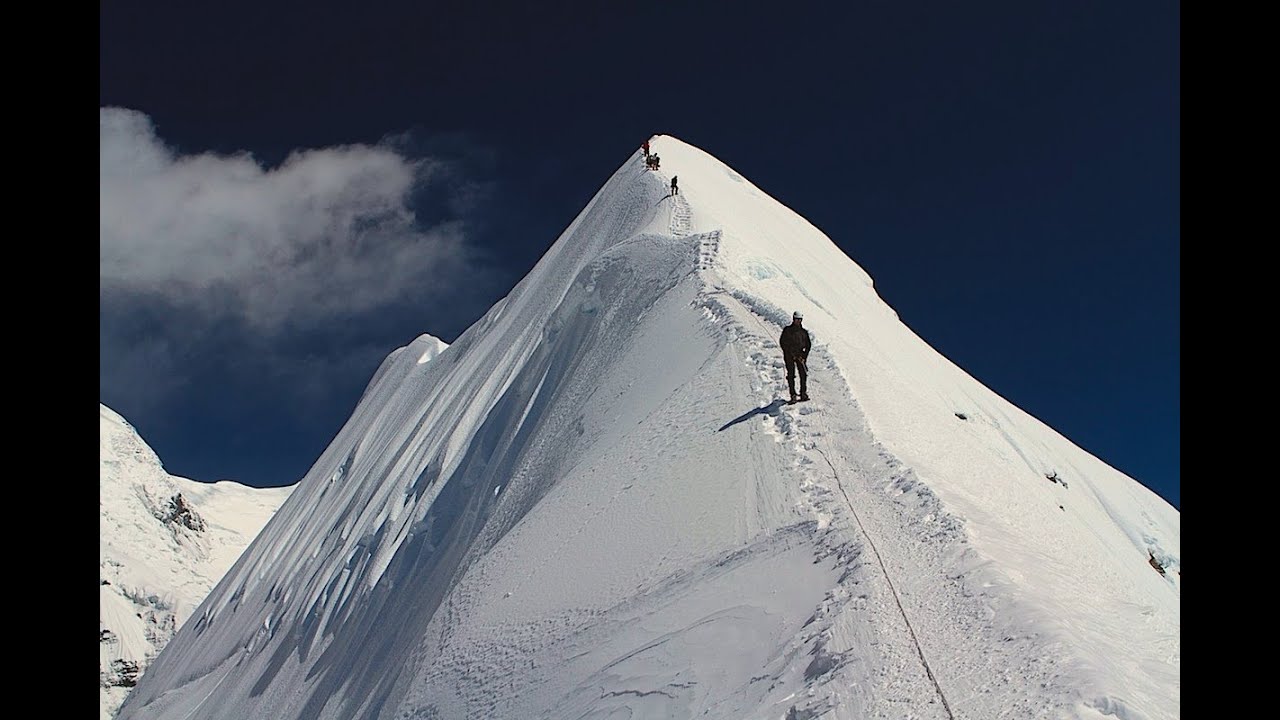
Today we ascend Saribung and then descend across the pass that leads to Mustang and DamodarKhund. We will leave early in the morning, climbing the slopes to the Saribung La (6000m). These slopes are not steep but we will rope upfrom camp as we will need to ascend carefully through the crevassed route. Depending on snow conditions it willtake two to three hours to reach the pass. From here the slope gets a little steeper and the summit of Saribung should be reached in a further two hours. The views are sensational looking north to Tibet and to the west to ouraudacious route back to Jomsom via Damodar Khund. From the summit we retrace our steps back to the pass forthe descent to the western watershed. Whilst we are climbing our Sherpa team will secure the route and assistthe porters across the pass. The descent to our camp on the moraines north of the pass should take a further two hours or so. Meals included: B, L, D
Now we head down the glacier with magnificent views of Khumjungar Himal (6759m) and Chhiv Himal(6591m) dominating the skyline views. The trail is good to start with, winding past spectacular penitentes of ice on the glacier, but then it becomes rough going on screes until we reach the frozen lake at the snout of the glacier.After the lake, we steadily descend on narrow trails until we reach Damodar Khund in the afternoon. The lake is a particularly holy site for Hindu pilgrims who make the arduousjourney during the month of August for the annual full moon festival held here. We continue to an excellent campsite near a small stream about half an hour past the lakes. Meals included: B, L, D
After two long days we take a rest day at this attractive spot so that we can explore and recuperate. There are blue sheep here and fossil beds with ammonites on the hillside opposite our camp. Meals included: B, L, D
Because we are now on the pilgrim trail the track improves, except for the first section, which has been destroyed by a massive landslide and needs to be circumvented.After that, we climb steadily in a spectacular brown landscape to a high pass at 5495m.Clouds permitting, there are views of Dhaulagiri (8167m) to the south and the now familiar peaks of the Damodar Himal behind us. From the pass we plunge dramatically down to our campsite in the bed of the Pharse Khola. Meals included: B, L, D
From Pharse Khola we climb steeply westwards to cross an un-named 5300m pass, then drop down a frozen river to the pilgrim huts at Ghumna Thanti. Then it’s over one morepass before we begin a long descent towards the unique villages of the Trans HimalayanMustang region. The scenery is dry and arid and the villages reflect a Tibetan lifestyle from abygone era. When we reach the river upstream from Yara, we have the opportunity to visit the ancient gompa at Luri, famous for its spectacular location amongst rock pinnacles and its 14th century paintings.Yara is about an hour further on and we will camp in the courtyard of a large house in the village. Meals included: B, L, D
From Yara, the trail traverses relatively flat country until after about two hours we suddenly find ourselves on the brink of a deep river gorge.Descending steeply, we cross the river then climb for an hour or so to another pass before dropping again to another relatively flat section of trail.The trail climbs again to another, lower, pass before finally descending through a windy gap in the rock pinnacles to the fascinating village of Tangge, where we camp.Tange is a very unspoiled Mustang village with a number of interesting chortens. Meals included: B, L, D
Trek to Lo Manthang and Explore the oldest Monastery, cave and so called the mini Tibet kingdom of Nepal. Meals included: B, L, D
Drive to Chhusang. Meals included: B, L, D
From Chhusang, we travel by jeep to Jomson, our lodge and hot showers. Meals included: B, L, D
In the early morning we take a spectacular flight back to Pokhara and arrive in the mid-morning.We stay at the Hotel Barahi or similar which is located close to the lakeside. After a welcomed shower, we have the rest ofthe day free to relax by the pool or do some exploring. The lakeside area has good shopping opportunities and internet cafés. It is worth while hiring a boat for a row out on the lake (Phewa Tal), which is the second largest in Nepal. Pokhara hasan interesting old area as well as an elaborate Hindu temple and a Buddhist monastery. There are various small museums scattered around town including the International Mountain Museum, which is well worth a visit. In theevenings there is the option of dining out at some of the many lakeside restaurants. Meals included: B
After breakfast we transfer back to the airport for our flight to Kathmandu. On arrivalin Kathmandu we are met and transferred back to our hotel. The rest of the day is free for shopping or further sightseeing. Located in the south of the city, Patan is also worth a visit with its own DurbarSquare full of historic structures and statues of past kings. Our final night in Kathmandu gives us a chance to go out on the town and enjoy a final dinner with our travelling companions and new-found friends. Meals included: B
Our trip ends today after breakfast and those leaving immediately are transferred out to the airport for your flight home or your onward journey.
SUGGESTED CLOTHING AND EQUIPMENT LIST
Head:
Sun hat or scarf
Light balaclava or warm fleece hat
Sunglasses with UV protection
Lower Body:
Under Garments
Hiking shorts
Lightweight cotton long pants
Light and expedition weight thermal bottoms
Fleece or wool pants (seasonal)
Waterproof (preferably breathable fabric) shell pants
Feet:
Thin, lightweight inner socks
Thick, warm wool hiking socks
Hiking boots with spare laces
Camp shoes (sneakers and/or sandals)
Gaiters for hiking in winter to the base camp
Upper Body:
T-shirts
Light and expedition weight thermal tops
Fleece jacket or pullover
Fleece Wind-Stopper jacket (optional)
Waterproof (preferably breathable fabric) shell jacket
Down vest and/or jacket *
Hands:
Lightweight gloves
Heavyweight gloves or mittens with a waterproof shell outer (seasonal)
Accessories:
Sleeping bag *
Headlamp (e.g. Petzl Zoom) with spare bulbs and batteries
Trekking Bags/Duffel bag *
Basic First Aid Kit
Large plastic bags – for keeping items dry
Daypack (approximately 2500 to 3000 cubic inches)
Trekking Poles
Water bottle (2) or camel bag
Toiletries (Small wash towel, Toilet papers etc)
Ear Plug (who know some people on group are snoring)
Toiletries:
1 medium sized quick drying towel
Tooth brush/paste (preferably biodegradable)
Multipurpose soap (preferably biodegradable)
Deodorants
Nail clippers
Face and body moisturizer
Feminine hygiene products
Small mirror
Personal Hygiene:
Wet wipes (baby wipes)
Tissue /toilet roll
Anti bacterial hands wash
Extras/Luxuries:
Binoculars
Reading book
Trail Map/Guide book
Journal & Pen
Gadgets – music and communication
Pencils and small notebooks
Travel game i.e. chess, backgammon, scrabble, cards etc
Please note:
The gears with an asterisk (*) sign are handed out by Himalayan Hikers as a part of service You can use your personal gears if you prefer to do so i.e. sleeping bag, liner, down jacket